Climate Projection
INTRODUCTION
Future climate projection information at local and regional scales is the basis for assessment of impacts of climate change in future periods at a locality, on key sectors, infrastructures, livelihood, communities especially vulnerable communities or any other important entity. Information on how climate hazards in future period is used together with exposure and vulnerability to determine the level of risk of climate change impacts. Increases in global mean temperature because of increases in the concentration of greenhouse gases in the atmosphere would alter the frequency and intensity of extremes in future periods. Heatwaves, floods and droughts would become more intense and frequent. For example, the latest IPCC AR6 WG1 report indicated that a 50-year heatwave event that occurred once in a climate without human influence is projected to be 4.8 times likely to occur in 1.0°C of global warming, 8.6 times in 1.5°C, 13.9 times in 2.0°C and 39.2 times in 4.0°C. Impacts of changing climate, especially on extremes must be assessed, particularly at 1.5°C and 2.0°C thresholds of Paris Agreement so that information generated from this exercise can be used for both strengthening mitigation, to ensure warming can be capped below the thresholds, and for adaptation to increase climate resilience in the event global warming goes beyond the thresholds. In the case of assessment of impacts in Muda and Kelantan river basins, future climate change information will be generated and provided to Project 2 (Water Balance) and Project 3 (Health) for respective assessment of impacts and risks. Project 4 integrates information from these projects in assessing the socio-economic impacts.
OBJECTIVES
The objectives of the Project:
- To evaluate the performance of CMIP6 GCMs in simulating regional and local climate, and select some models for regional climate downscaling.
- To carry out high-regional climate downscaling (5 km) and used these to evaluate the changes of weather and climate extremes under global warming 1.5°C and 2.0°C in the study areas.
- To investigate the drivers of changes in weather and climate extremes including the roles of monsoon changes under global warming 1.5°C and 2.0°C.
- To develop an impact and risk-based early warning system of weather and climate extremes over Muda and Kelantan river basins.
METHODOLOGY
Climate projection is generated by using global climate models (GCMs) forced by GHG emission scenarios. For consistency and better coordination, simulations of future climate at global scales are coordinated by the World Climate Research Programme (WCRP) of the World Metrological Organisation (WMO), through a Project called the Coupled Model Intercomparison Project ( CMIP). This is carried out in a cycle that is more or less coincided with the cycles of the IPCC Assessment. For example, CMIP6 caters for the requirements of the IPCC AR6 cycle.
In a climate change impact assessment, which is usually carried out at local or regional scales, climate projections based on GCMs are usually too coarse for such purposes, the model resolution is in the order of 100 – 300 km. A GCM at that resolution does not “see” coastlines and mountains well. To suit the requirement of local assessments, GCM projection outputs must be “refined” through a procedure known as “downscaling”. One method of downscaling is dynamical downscaling which involves nesting of a Regional Climate Model within the GCM (Tangang et al. 2021). To ensure projection robustness and estimation of uncertainty, many GCMs, RCMs and multiple emission scenarios would have to be considered. This makes regional climate downscaling resource expensive and time consuming to implement. Much like CMIP for GCM projections at global scales, downscaling at regional scales is coordinated by the Coordinated Regional Climate Downscaling Experiment (CORDEX), a programme under WCRP. CORDEX advances the science and applications of regional climate downscaling through global partnerships. In the Southeast Asia, this is coordinated under the CORDEX Southeast Asia (CORDEX-SEA).
Project 1 takes advantage of CORDEX-SEA simulations of both CMIP5 (Tangang et al. 2020) and those of CMIP6. However, with a resolution of 25 km, CORDEX-SEA projections can still be considered coarse for basin-scale impact assessment. Hence, in this Project, CORDEX-SEA simulations will be further downscaled into 5km resolution over Peninsular Malaysia. In a way, this Project also contributes in CORDEX-SEA simulations of CMIP6 at 25 km.
Further downscaling of a number of CORDEX-SEA simulations using at least two RCM (RegCM4.9 and WRF) will be carried out over Peninsular Malaysia at 5 km resolution. These simulations will be implemented until a period when the global temperature reaches the thresholds of 1.5°C and 2.0°C, which corresponds to around 2040-2050 (depending on GCMs and emission scenarios). Further analyses would then be carried out on future changes (including extremes) over Peninsular Malaysia as well as over Muda and Kelantan river basins when global warming reaches 1.5°C and 2.0°C. Key information on future climate change over Muda and Kelantan river basins will be provided to Project 2 and 3 for their respective impact assessments. Downscaled climate data over Peninsular Malaysia will be provided and archived in NAHRIM climate data repository. Future climate change over Kalimantan and Sumatra is of interest. As in the present climate, drier condition in these regions in future periods would likely influence air quality in Peninsular Malaysia. The other component of this project is to develop a risk and impact-based forecasting model of weather and climate extremes over Muda and Kelantan river basins for sub-seasonal to seasonal (S2S) timescales.
Overall Project 1 will be implemented in Four Phases:
Phase 1: Assessment of weather and climate extremes in the past 30 years will be carried out in the two study areas based on observed meteorological data, which will be obtained from Malaysian Meteorological Department. CMIP6 climate downscaling simulation preparatory steps including selection of models, data downloading, analysis on CMIP6 models in terms of their ability to simulate the climatology and variability patterns e.g. ENSO will be carried out. In this phase “Data Handshake” will take place where existing CORDEX-SEA data 5 km including those provided by CSIRO (bias and unbias-corrected data) and also extreme indices for the three areas. Climate projection data based on CORDEX-SEA 25 km will also be provided to Project 3 as input to the Air Quality Model.
Phase 2: Regional climate downscaling of CMIP6 models of 25 km and 5 km will be carried at UKM, NAHRIM, MMD and INOS UMT. Possible contribution of additional runs from RU-CORE Bangkok Thailand will be received as well. Analysis of model outputs, model performances, bias-correction and calculation of extreme indices will be carried out. Second “Data Handshake” will be implemented at this phase where the respective model information fromCMIP6 downscaling will be provided to Project 2 and 3.
Phase 3: Further analysis on relative influence of ENSO and GW1.5/2.0C will be implemented. Also, drought conditions over Kalimantan and Sumatra during GW1.5/2.0C will be assessed based on the outputs of CORDEX-SEA 25 km and CMIP6 downscaling of 25 km. In this phase, preparatory works on developing meteorological forecasts of weather and climate extreme will be carried out. This includes downloading archived CFSv2 forecasts and calculating relevant extreme indices.
Phase 4: In this phase the work on developing meteorological forecasts of weather and climate extremes by downscaling the forecasts to the three study areas will continue. Skills for forecasts at sub-seasonal to seasonal timescales will be evaluated. Third “handshake” will occur here where Project 2, 3 and 4 will provide matrices of risk and impacts which will be incorporated to the meteorological forecasts to form the Impact-Risk Based Early Warning System (IR-EWS) of weather and climate extremes.
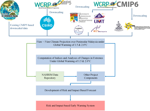
Flow-chart indicating the overall implementation of Project 1 .
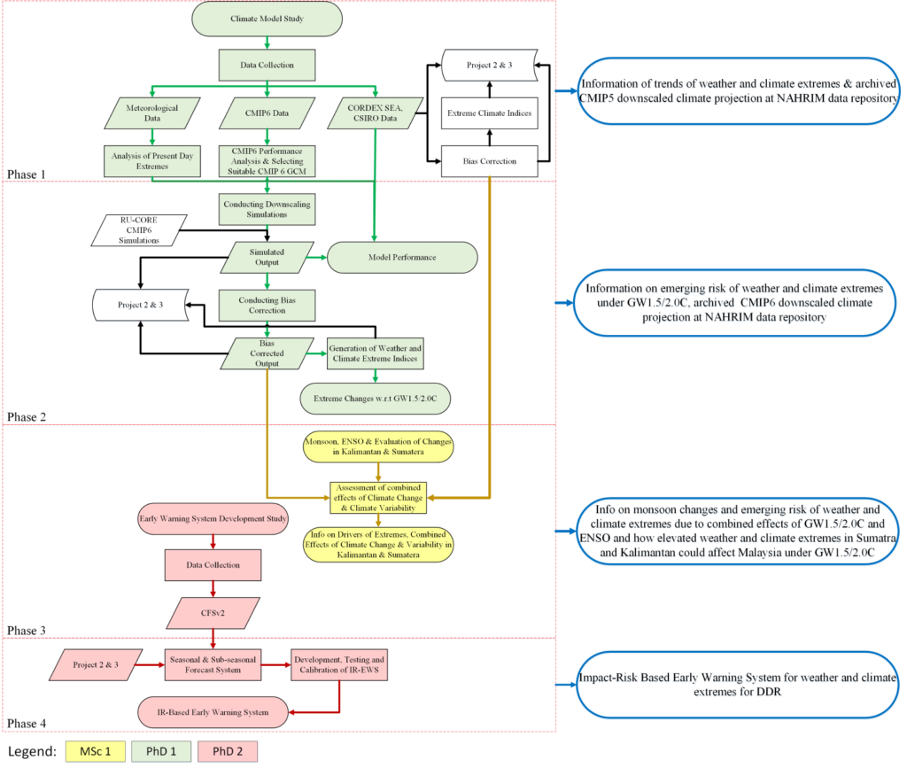
Detailed flow-chart of Project 1 indicating the four phases and components of the Project.
KEY PROJECT MEMBERS


ASSOC. PROF. DR. LIEW JUNENG
Co-Researcher

DR. CHUNG JING XIANG
Co-Researcher
Universiti Malaysia Terengganu

MR. MUHAMMAD AMMAR FIRDAUS ABDULLAH
Malaysian Meterological Department

DR. ESTER SALIMUN
Co-Researcher
Universiti Kebangsaan Malaysia

MR. MOHD SYAZWAN FAISAL MOHD
NAHRIM

PROF. DR. MOHD FADZIL AKHIR
Co-Researcher
Universiti Malaysia Terengganu

DR. teachn MARZUKI
Universitas Andalas, Indonesia

DR. SUPARI
Indonesian Agency for Meteorology, Climatology and Geophysics (BMKG)
COLLABORATORS
International

DR. JOHN McGREGOR
CSIRO Australia

DR. JERASORN SANTISIRISOMBOON
STUDENTS

ABDUL AZIM BIN AMIRUDIN
PhD
Thesis title: Projection of Climate Extremes over Peninsular Malaysia under Global Warming 1.5°C and 2.0°C based on high-resolution climate downscaling.
Universiti Kebangsaan Malaysia

AFIQAH BAHIRAH AYOUB
PhD
Thesis title: Development of Extreme Events Early Warning System for Sub-seasonal to Seasonal timescales over Peninsular Malaysia.
Universiti Kebangsaan Malaysia

MUHAMMAD AMIRUL HAKIMI BIN ABDUL HALIM
MSc
Thesis title: Observed and Projection of Weather and Climate Extremes in Peninsular Malaysia, especially in Kelantan and Muda River Basin when Global Warming Reaches 1.5°C and 2.0°C.
Universiti Kebangsaan Malaysia

NEW XIA YAN
BSc
Thesis title: Analysis of weather and climate extremes based on observed data over Muda and Kelantan river basins
Universiti Kebangsaan Malaysia
GROUP ACTIVITIES
LRGS Project 1 Inception Workshop
