Programme
INTRODUCTION
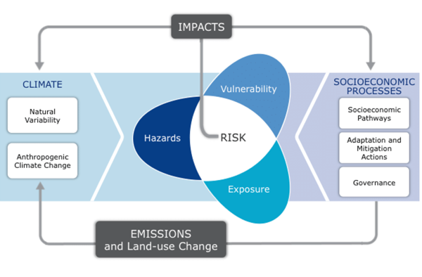
Malaysia has been experiencing upward trends in the temperature-related indices in the last 3-4 decades (Tangang et al. 2007; Tan et al. 2021). Many of the climate-related disasters during past decades in Malaysia, such as floods and droughts, could have been amplified by the anthropogenic climate change, although they could also be due to the climate variability (Tangang et al. 2012). Regardless, the level of risks of climate impacts of global warming beyond 1.5 and 2.0°C on critical sectors, including socio-economic and people’s livelihoods, needs to be assessed and understood. However, different regions or sectors, could have different levels of risk of climate change impacts. A specific impact assessment study would need to be carried out for a particular region or sector.
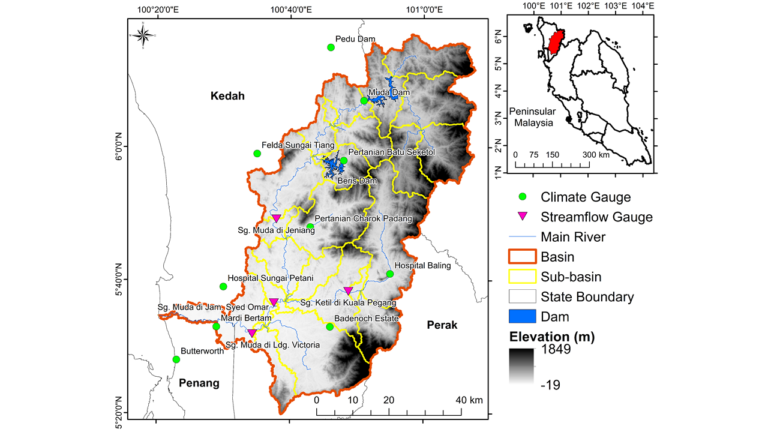
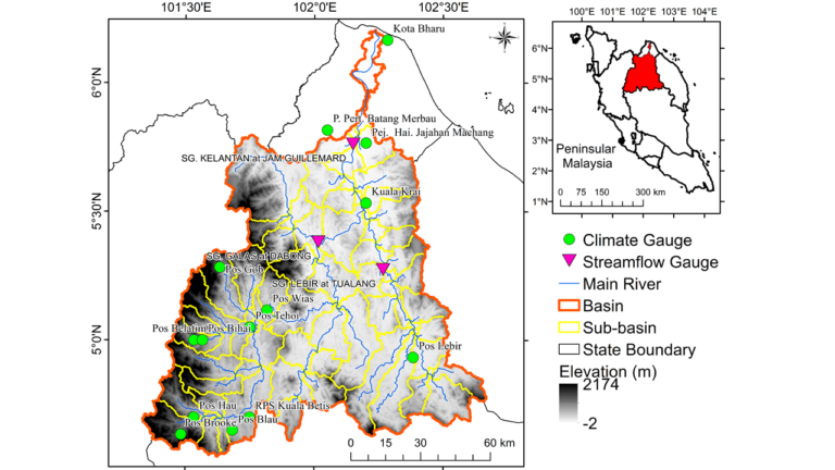
This Research Programme, entitled “Assessment of Impacts of Global Warming of 1.5°C and 2.0°C on Water Balance, Health and Socio-Economic Implications in the Kelantan and Muda River Basins”, aims to carry out a Vulnerability, Impact and Adaptation (VIA) assessment study at these two very important river basins (See Figures below). It was established and funded by the Malaysian Ministry of Higher Education (MOHE) under the Long-term Research Grant Scheme (LRGS) for a study period of four years beginning December 1, 2020. This is a multidisciplinary study that comprises and interconnects four main project components: Project 1: Regional Climate Projection to provide high resolution local climate projection; Project 2: Hydrological modeling for water balance assessment; Project 3: Assessment of health impacts due to climate and hydro-climate extremes; Project 4: Assessment of Socio-Economic impacts. The leading institutions include Universiti Kebangsaan Malaysia (UKM), Universiti Sains Malaysia and Universiti Putra Malaysia. However, members and collaborators of the projects come from various universities, government agencies, private company, NGOs or even international universities and institutions.
OBJECTIVES
- To generate, archive and disseminate multi-model and local scales climate change projections, assess elevated changes, and emerging risks of weather and climate extremes under Global Warming 1.5° 2.0°C, quantify the driver of changes and develop impact – risk based weather and climate extremes early warning system.
- To assess the impacts and risk of elevated changes of weather and climate extremes under Global Warming 1.5°C and 2.0°C on water balance, health and their associated socio-economic implications.
- To generate evidence based inputs, guidance and recommendations with regards to the elevated changes and emerging risk of weather and climate extremes and their impacts under Global Warming 1.5°C and 2.0°C for climate change policy in Malaysia.
WHY THIS RESEARCH PROGRAMME IS IMPORTANT?
COMPONENTS AND CONNECTIVITY
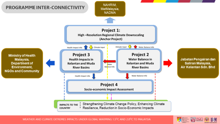
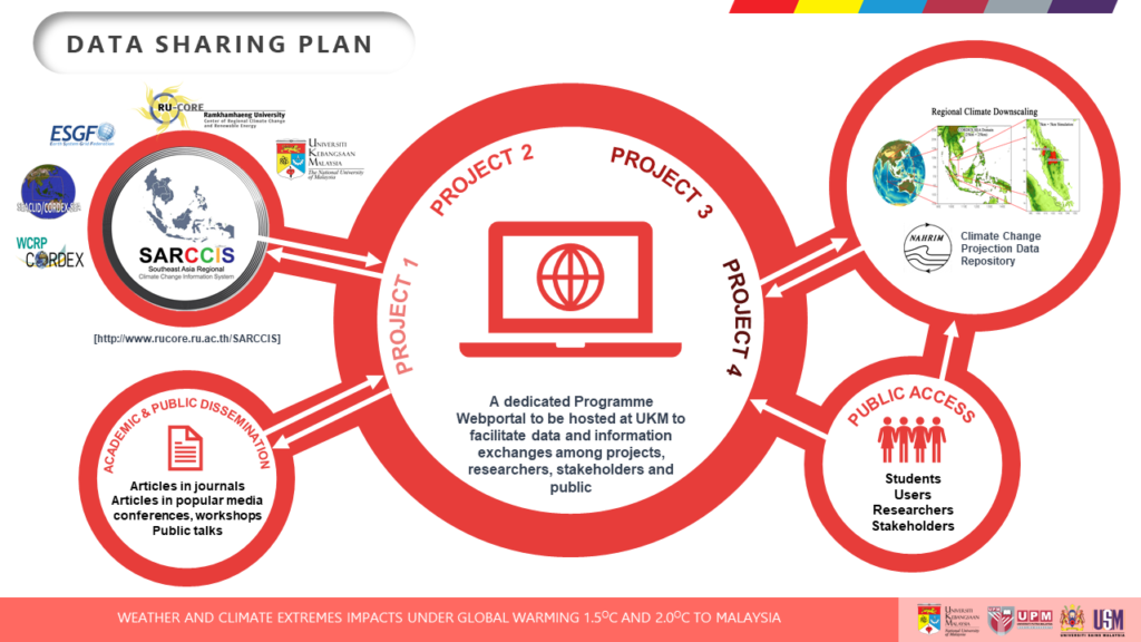
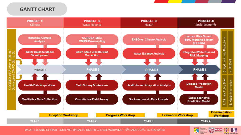
The above figure illustrates the component of this LRGS research programme and the connectivity among projects. Project 1 focuses on downscaling a number of CMIP6 GCMs to a resolution of 5 km over Peninsular Malaysia domain. Projection of weather and climate extreme will be made for the period when global warming reaches 1.5°C and 2.0°C thresholds. These will become inputs to Project 2 and 3. Project 2 will be focusing on assessing the impacts of global warming 1.5°C and 2.0°C on water balance by creating water balance model, investigate potential sub-basin scale water yield and streamflow changes and create water stress index and flood index for a water disaster risk map. Information from Project 1 and 2 will be used by Project 3 in assessing health impacts over the two basins. The key outputs from Project 2 and 3 will become inputs to Project 4 that will be assessing the impacts of global warming 1.5°C and 2.0°C. The outputs of Project 2 and 3 will also become inputs to Project 1 which will be formulating a risk-based and impact early warning system for weather and climate extremes. The figure below depicts how this programme connectivity with other projects, data exchanges and the roles of programme’s website connecting to stakeholders. Overall, the implementation of the programme is depicted in the Gantt Chart.
Connectivity and Data Sharing
GANTT CHART
EXPECTED OUTCOMES
- Projected weather and climate extremes over Peninsular Malaysia, including over MRB and KRB, when global warming reaches 1.5°C and 2.0°C thresholds.
- Projected climate data based on multi-model downscalings (various variables including precipitation, temperature, winds, solar radiation, etc) at 5 km resolution under global warming 1.5°C and 2.0°C.
- Impact and risk-based early warning system on weather and climate extremes over MRB and KRB
- Projected impacts on water balance and flood – water stress index for integrated water disaster risk map.
- Climate driven disease predictive model and health impacts under global warming 1.5°C and 2.0°C.
- Socio-economic impacts predictive model under global warming 1.5°C and 2.0°C.
- Adaptation measures for inputs to strategy development facing global warming 1.5°C and 2.0°C.
- Capacity building (MSc and PhDs)
- Scientific papers in high-impacts journals and policy brief / papers.
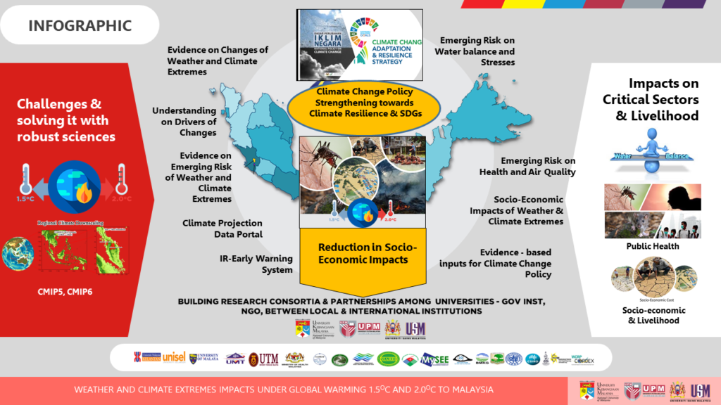
PROGRAMME INFOGRAPHIC
PROGRAMME AND PROJECT LEADERS

UNIVERSITI KEBANGSAAN MALAYSIA

DR. TAN MOU LEONG
Project 2 Leader
UNIVERSITI SAINS MALAYSIA

ASSOC. PROF. DR. NORFAZILAH AHMAD
Project 3 Leader
UNIVERSITI KEBANGSAAN MALAYSIA

DR. NIK AHMAD SUFIAN BIN BURHAN @ JAOHARI
Project 4 Leader
UNIVERSITI PUTRA MALAYSIA
FORMER PROJECT LEADERS

PROF. DR. ASNARULKHADI ABU SAMAH
Former Project 4 Leader
UNIVERSITI PUTRA MALAYSIA
